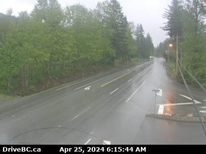

Chilliwack, BC
Hwy-7 (Lougheed Hwy) at Highlands Blvd, approximately 3 km east of Harrison Mills, looking east. (elevation: 70 metres)
Hwy-7 (Lougheed Hwy) at Highlands Blvd, approximately 3 km east of Harrison Mills, looking east. (elevation: 70 metres)

Chilliwack, BC
Chilliwack › West: Hwy 7 (Lougheed Hwy) at Highlands Blvd, approximately 3 km east of Harrison Mills, looking east
Chilliwack › West: Hwy 7 (Lougheed Hwy) at Highlands Blvd, approximately 3 km east of Harrison Mills, looking east

BC
Harrison Mills › West: Pilots' Loft
Harrison Mills › West: Pilots' Loft

BC
Minto Landing: Sandpiper Golf Resort
Minto Landing: Sandpiper Golf Resort

Chilliwack, BC
Hwy-1 at Prest Rd, Chilliwack, looking west. (elevation: 19 metres)
Hwy-1 at Prest Rd, Chilliwack, looking west. (elevation: 19 metres)

Chilliwack, BC
Hwy-1 at Prest Rd, Chilliwack, looking south. (elevation: 19 metres)
Hwy-1 at Prest Rd, Chilliwack, looking south. (elevation: 19 metres)

Chilliwack, BC
Hwy-1 at Prest Rd, Chilliwack, looking east. (elevation: 19 metres)
Hwy-1 at Prest Rd, Chilliwack, looking east. (elevation: 19 metres)

Chilliwack, BC
Hwy-1 at Prest Rd, Chilliwack, looking north. (elevation: 19 metres)
Hwy-1 at Prest Rd, Chilliwack, looking north. (elevation: 19 metres)

BC
Kent › North: Hwy 9, north end of Agassiz-Rosedale Bridge, looking north
Kent › North: Hwy 9, north end of Agassiz-Rosedale Bridge, looking north

NS
Rosedale › South: Hwy 9, north end of Agassiz - Bridge, looking south
Rosedale › South: Hwy 9, north end of Agassiz - Bridge, looking south

BC
Kent › East: Hwy 7 at Hwy 9 (Evergreen Drive) in Agassiz, looking east
Kent › East: Hwy 7 at Hwy 9 (Evergreen Drive) in Agassiz, looking east

Agassiz, BC
Hwy-7 at Hwy-9 (Evergreen Drive) in Agassiz, looking east. (elevation: 24 metres)
Hwy-7 at Hwy-9 (Evergreen Drive) in Agassiz, looking east. (elevation: 24 metres)

Chilliwack, BC
Chilliwack › North: Hwy 9, at the north end of Rosedale Overhead, looking north
Chilliwack › North: Hwy 9, at the north end of Rosedale Overhead, looking north

Chilliwack, BC
Chilliwack › South: Hwy 9, at the north end of Rosedale Overhead, looking south
Chilliwack › South: Hwy 9, at the north end of Rosedale Overhead, looking south

Chilliwack, BC
Hwy-1 at Annis Rd, looking west. (elevation: 15 metres)
Hwy-1 at Annis Rd, looking west. (elevation: 15 metres)